Lessons from the Sawtooth Wilderness
- scottsweet7

- Jul 7, 2023
- 10 min read
5 days, over 30 miles, and thousands of feet of elevation gain and loss each day. This backpacking trip marks a turning point in my life. For me, the Sawtooths have become a place of rebirth and renewal. I felt as though I had come home to a place I never knew.
Les Stroud, a.k.a. Survivorman, speaks of a "bad lemon" concept in a TV episode of his highlighting tragedy that struck a young man while backpacking in Patagonia. This "bad lemon" strategy of recognizing your limits essentially boils down to your ability to check your machismo at the door and take note of your circumstances and environment. When something goes awry, even in a small way, this could be considered a "bad lemon" or half of one. Once 3 bad lemons occur on your trip, you call it. Turn around, pack it all up and pack out, and do whatever you can to wrap up the trip. When you push yourself beyond your limits, especially after already dealing with bad lemons such as blisters, dehydration, etc., you may find the predicaments ahead too great to overcome. A small problem can snowball into a large problem very quickly, especially in the backcountry, where help is miles away. On this trip, our bad lemons turned a 50 mile trip into 30. Weak knees, a sensitive stomach, and snow beyond our initial expectations, led to a tough decision on day two to cut our trip in half, where we would exit at Redfish Lake rather than Petit Lake. I do not know what would have happened if we had continued all the way, and frankly I don't really care to know. I am grateful to know I can return after this and finish the trip another time.
I will break down our trip into each day, and discuss the route we chose to follow:
Day 0: We arrived in Stanley late Saturday afternoon, and drove to the Iron Creek trailhead to find a spot to camp. The trailhead campsites were completely full leaving us little choice but to backtrack out of the foothills and back on the highway. We found a forest road northwest of Stanley where we had access to the National Forest and undesignated camping spots. The road is USFS Rd 642. Our understanding was that it is open to the public. You may you want to confirm that before following suit. Generally the forest roads offer access to camping when all other options are exhausted. Just be careful of wildlife, and don't burn the forest down with careless campfire habits.
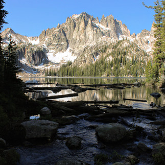
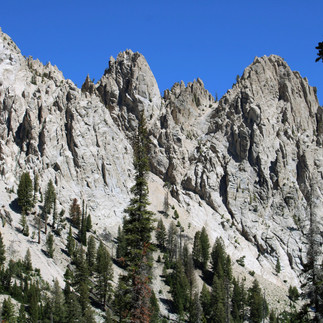
Day 1: We began our trek at Iron Creek Trailhead with the intention of exiting at Petit lake in 5 days. Jacob's wife dropped us off and was to pick us up again as my car is in the shop this week. We hiked up about 1700 feet in elevation to Alpine and Sawtooth lakes, crossing streams and creeks, snow patches, and navigating many switchbacks. A big theme of this trip was switchbacks and water crossings. Our daily average distance turned out to be about 6 miles. (After we chose to shorten the trip). Lunch was on the shores of Alpine Lake, a stunning tarn just below Sawtooth Lake, nestled tightly in a small glacial carved valley. The hike up to Alpine followed a bold and jagged ridgeline or arete with our trail eventually providing views of Stanley in the distant valley below. This overlook was the last cell service we had until the end of Day 5. We spent our first night on the southeastern shore of Sawtooth Lake. The lake still has floating ice, so we didn't swim as planned. (In fact the only lake we swam in was Redfish on the last day, and that was still cold!) There are no fires allowed within 200 yards (or feet, can't remember) of the lake, so all our cooking was done using a propane powered Jet Boil. I managed to find adequate trees for hammock camping every night, while Jacob slept in his lightweight tent.
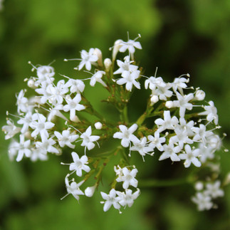
Day 2: We embarked on our downhill excursion day 2 with the intent to complete 11 miles to Baron Lake. Plans changed. The initial views past Sawtooth Lake are some of our favorites of the trip! Tarns and expansive alpine views made the trip worth it and the packs feel lighter! Then we descended into the valley. It quickly became clear that we had left the well-traveled trails of the front country as we began bushwhacking through dense thickets every couple hundred feet. We crossed creek after creek over grown by bushes and tall grasses. It was muggy, slow going, and tough on the knees. We even had to take off the boots and cross a raging section of stream that was too deep to navigate without the risk of wetting our boots. By the time we lumbered into our lunch spot at the base of the valley, we were exhausted! We agreed to take a long lunch, but my back was incredibly sore, and knees shaky. We hadn't yet calculated the amount of uphill we needed to do, but we knew we still had over 5 miles of trail left for that day and it was already 1:30 pm. The downhill portion saw a loss of over 2500 ft. The uphill ahead was another 3100 ft., with 1800 of that being done in the switchbacks of the last mile. That was not going to happen in one day. This is when a tough decision had to be made. We counted our bad lemons, took note of our ability to handle each one, then called it. I took a 4 hour nap in the hammock to recover, we set up camp, and passed out. That was a discouraging night, but not altogether bad. The camp area was nice, we were safe, and slept well. The wildflowers also can not go without being noticed, they were not overly abundant, but their presence helped raise the mood, and beautify the sometimes dreary trail. My favorites: Indian Paintbrushes, were found all across the 30 miles we trekked!
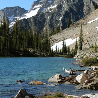
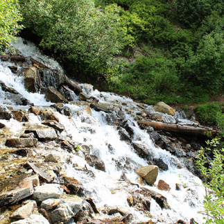
Day 3: Our hardest day of the trip. 3100 feet of gain in front of us, we set off hopeful and confident we could accomplish the task at hand. With the understanding we would be doing half the miles in total, we were relieved. The hike was mostly through forest, but washes, gullies, and slide areas opened up the trees providing 360 degree views of towering peaks and ridges all around us. We loosely followed the Baron creek below, all the way to Baron Creek Falls falling over the headwall of the valley. Other waterfalls fell out of adjacent hanging valleys, making the scene all the more magical. Switchback after switchback awaited us after lunch in the forest. Our view peaked above Baron Creek Falls as we peered back on the 3000+ vertical feet we hiked. It was quite the feeling to be done with all that! The hike to the Baron Lakes was nice, following the upper creek through meadows and marshlands, up a few more switchbacks, then finally emerging at the most beautiful alpine lake I had ever seen! Jacob has backpacked in places such as Banff, the Wind Rivers, The Pyrenees of Spain, Glacier National Park, and much more. Still, he placed Baron Lake in the top 10 alpine lakes he had ever seen! The pictures don't provide the full immersion that you get after finishing a difficult hike and as you rest on the banks of the lake. It was beautiful! We wish we had planned a 0 day or a non-hiking day at that lake. We spent the night there watching waterfowl fish in the chilled water, and the evening light wane on the sharp peaks.
Day 4: The morning of Day 4 was met with a remarkable sunrise on Baron Lake! The reflection was perfect. Our journey then took us up more switch backs to Upper Baron Lake, then a high mountain pass at over 9000 ft. This pass was another favorite of ours as we beheld the entirety of the southern half of the Sawtooth Range expand before us reaching each horizon in our 180 degree field of view. Behind us, the Baron Lakes, the valley we had hiked the day before, and distant peaks to our north lay in view. The pass was a place of incredible peace and awe-inspiring wonders. We hiked down to Alpine Lake (a different one than that of Day 1) to have lunch. There, diarrhea set in, and my mood quickly changed. It was time to get to the front country. After taking a few Pepto pills, we marched out the last 4 miles to the Redfish Inlet Campground. In total, Day 4 was our longest hiking day of 8 miles. The campground was surprisingly empty. We encountered a few day hikers leaving by ferry from the inlet to the boat docks on the other end of the lake. The evening was spent around a campfire, playing in the lake, and stargazing. 4 deer spent hours at the campsite with us, with two yearlings playfully darting back and forth while their mother looked on. It was peaceful, and assured us no dangers were present.
Day 5: We slept in till 9, rather than waking up with the sun around 6. I woke to the sound of the ferry arriving at the shore to drop off more day hikers. We were initially looking at a 5 mile trek out over the tall moraine bounding Redfish Lake to the north, but after a short discussion, we felt it would be way nicer to have the lake breeze blow through our hair on a boat than carry those packs any further. The ferry usually runs at 9, noon, 3, 5, and 7, but because of the volume of day hikers in the morning, the small pontoon/speed boats they used for the ferry couldn't carry everyone and returned multiple times at and a little after 9. We took the ferry back to civilization then spent 3 hours on the beach. Though not the rugged end to this backpacking trip you might of expected, a lake day, and pizza in Stanley hit the spot!
Side note: The only established bathrooms we had were at the trailhead, or at and around Redfish Lake. All other potty experiences were those in the great outdoors. Bring more toilet paper than you think you'll need!!! We both ran out, and I had brought an entire roll. We used it for clearing our noses and such too and didn't expect to run through it that quickly.
Gear:
The right gear can make all the difference. Weight, quality, durability, usability, etc., all play a part into separating the mediocre gear from the gear that could make a trip good or even save your life.
I began the trip carrying a little over 60 lbs. (backpack included) At the end of the trip and after eating our food and emptying the water pouches, I was down to just above 50 lbs. Weight matters! As Jacob says: Pounds equal ounces, and ounces equal pain. My target weight at the beginning of the trip was 55 lbs. With hindsight, I would say aim for under 50.
Gear that made the most difference on this trip:
- Garmin SAT Phone (connects directly to satellites and has a SOS button in case of emergency, can send and receive text messages) ~$600
- Thermo-rest pad (makes for warm nights by reflecting body heat) ~$30
- Winter sleeping bag (rated to 0 degrees or less) ~$100
- Jet Boil (Quickly boils water in under 2 min, use already filtered water. Works great with Mountain House meals and oatmeal and hot chocolate) ~$175
- Water Filters (Sawyer minis and a gravity filter) ~$35-60
- A good jacket and a beanie ~$30-50
- A durable framed backpacking backpack (75-85 L) ~$200
- Moisture-wicking, UPF protection, and tear resistant pants and shirt ~$300
- Good boots (worth their weight in gold, your feet are your most valuable resource, bad boots make for a bad time.) ~$60-180
- Appropriate meds (i.e. Ibuprofen, Pepto, Aspirin, etc.)
- A wide-brimmed sunhat (with a cord around your neck to stop it from flying away) ~$15-50
- Lightweight camp chair (feels incredible after hiking a long distance) ~$60
- Backpacking tent or hammock with a mosquito net and a rain tarp ~$50-200
- A reliable knife ~$35
- First Aid kit ~$35
- Sharpie ~$2
- Mountain House Meals (look for the ones with the most calories) ~$12/each
- Trail mix, fruit snacks, dense snack bars, oatmeal and hot chocolate, beef jerky, etc.
- Camp spork ~$2
- Camp cookware (2 plastic cups and a metal container for boiling water) ~$15
- Water shoes or sandals (great for river crossings and relaxing after a long day, give the boots time to air out) ~$15-50
- 50ft paracord ~$15
- Physical Topo map ~$15
- Headlamp ~$25
- Bear Spray ~$35
This isn't a complete list, but this gear made all the difference on our trip. You can add or take out what you choose. Just know sometimes the smallest comforts really boost the moral, but the added weight really hurts.
Check for sales from esteemed brands such as REI when looking for gear. Lightly used, or previous-year gear is still usable and could make all the difference! I bought some of my gear from Cabela's, off Amazon, and even from Walmart. Shop smart and do your research. What works for me may not work for you. Also, don't be afraid to borrow from people you trust if you don't have the budget right now.
This trip was one for the books! Though not what we had originally planned, it was still fulfilling and wonderful! I am grateful for Jacob and his patience, knowledge, love, respect, common sense, etc. There are few people I would have attempted this with. Good company made this adventure all the more sweet and memorable! I will cherish these memories for the rest of my life, and these sights will grace my dreams and inspire many paintings to come! From the sounds of bubbling creeks to the sight of towering and sharp snow covered peaks, my senses were filled with beauty every day. I felt I had shed the world and was finally one with the planet around me. I could not be prideful because I was merely a piece of the complex puzzle all around me. I was no better than the squirrels and butterflies. Yet, I was as valuable as every tree, flower, and stream. We were all adding and taking away. We were all living and dying. The cycle of life was tangible and beautiful. I thank all those who made this trip possible, and for the many people who have strived to maintain this Wilderness Area. I hope someday you too can see this place with your own eyes. Until then, enjoy a few pictures from the many I took!


Truly, a life-changing experience!
Tremendous write-up and photos❣️What gifts!!
Felt a bit, in a tiny way, we experienced it with you.
Very grateful you're back safe and unharmed, due to wise and diligent preparation, decisions, and time spent - making sure you didn't adventure alone, but went with experience and competence at your side.
As always, MUCH appreciation and joy in you sharing!!! 😊