The Grand Tour of East Idaho
- scottsweet7

- May 28, 2023
- 3 min read
Sunset is my favorite time to explore, with the waning evening light and "golden hour", evening is a magical time in East Idaho! It has been some time since I have seen the countryside at sunrise. Today was an early start at 4 am.
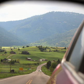
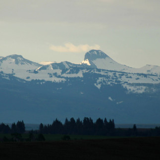
Headed north on Highway 20, I began the day's adventure by turning east onto Highway 32. I have done this drive many times before, but today's experience was near ethereal as the sunrays poured through the scattered blankets of clouds and painted the lush landscape below with soft morning light. The high peaks of the Tetons were mostly obscured by the drifting lenticular clouds giving place for the lower mountains and hills to take center stage thereby garnering my full attention. The greenery this spring feels unmatched compared to previous years as daily storms continue to water the vast landscape we call home. The Tetons loomed before me as I drove towards Teton Valley. With the morning light pouring from the east, the mountains appeared blue scaled and layered, with the soft whites of snow breaking up the skyline and thus revealing the intricate topography of the range.
From 32, I turned east onto Highway 33 and drove through Tetonia, Driggs, and Victor. In Victor, I turned right onto Highway 31 to Swan Valley taking the pass through the Big Hole Mountains. Rising fog rested just above the forests of the tight pass, and a raging stream coursed through the valley parallel to the road. Upon arriving in Swan Valley, I checked in on the Palisade Reservoir where I found it at about 95% capacity. A sight for sore eyes following several years of extremely low water levels. The water rushing from the bottom of the dam into the Snake raised a dense cloud of mist high above the river below. I then opted for a return to Idaho Falls via dirt back roads, hoping to connect with Skyline Ridge Rd (the one I drove a few days ago where I popped my tire).
Snake River Rd follows the river closely, paralleling highway 26 through Swan Valley, but on the opposite side of the river. This road provides access to Calamity Campground (though this side road is currently closed) on the reservoir, and Fall Creek Falls. The Falls have and incredible volume of water rushing over the cliffs above the Snake. Water is even flowing along the road and through paths that are normally dry and used as access points to view the falls. I would not recommend visiting the falls for a few weeks. Swimming is not a good idea in any of the waterways and water holes until mid-late June. I took Fall Creek Rd west through the hills for the first time, and was successful in reaching Skyline Ridge Rd! However, the road conditions in the backcountry are poor in areas, as frequent runoff has deteriorated the road edges, and in some areas, has carved deep ruts through the road. I was lucky to not break an axle hitting a deep rut (I was able to slow down, but not stop before hitting it). At some points, Fall Creek flows within a few feet of the road, and mountain springs emerge from the hills and flow right across the road creating deep puddles in the road. The final leg of the road becomes very steep as it connects to Skyline Ridge Rd. For the first time, I had to shift to my car's lowest gear to ascend this stretch. As it is Memorial Day Weekend, the campgrounds along Fall Creek were mostly full, with literal hundreds of campers, hikers, dirt bikers, and more scattered along the hills and within the trees along the water's edge.
All that being said, this drive has made it up to my top 10 favorite drives of all time! The locations, weather, time of day, and time of year, all added up to create a memorable experience I will not soon forget. In total, I drove over 200 miles, used a half tank of gas, and put more wear and tear on my sweet Rav4, Phoebe. Pros and Cons considered, this was a wonderful Sunday drive!
Enjoy a few pictures from the trip! Stay safe out there on this holiday weekend.


Very pleased it was so rewarding, refreshing and memorable for you!
The sunrise was stunning!!
Enjoyed the other diverse and beautiful photos too!
Thanks much for continuing to share!💗
Which photo will you paint of these?😉