New Roads
- scottsweet7

- Apr 26, 2021
- 3 min read
I have found the majority of my spots by simply driving a road I have never been on before. It is incredible what is hidden along the countless mountain roads and in the many canyons of Idaho. This most recent spot I found yesterday is only 45 min away from Rexburg and is accessed from the same roads that take you to Cress Creek and Kelly Canyon! I had never taken the time to follow the fork in the road to see where it went until now.
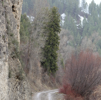
On Highway 26, which takes you to Swan Valley and the Palisade reservoir, there is a short time during which you pass the river tucked away several hundred feet below you in a canyon. I had always wondered how to get down there and what lay in store for me when I finally did. Well, now I know! This narrow canyon opens up into a broad braided river valley with several tributaries and streams running into and along side it. Many peaks, ranging from 8000-9000 feet on average, rise above the valley floor. Large basaltic and conglomerate cliffs border the dirt road that snakes along the river. South Snake River Road runs northwest/southeast along the Snake River and is the same road that gives access to Cress Creek, Kelly Canyon, and Stinking Springs recreational areas. This road passes a wide range of potential day activities such as golf, fishing, zip lining, skiing/snowboarding, hiking, boating, swimming, hot springs, mountain biking, and much more. Continuing southeast, the road enters the Wolf Flats and Warm Springs recreation areas. There are at least 3 hikes, and 2 side roads that snake off into the hills that can be accessed from these recreational areas. A variety of animals roam this area. On one 4 hour drive/adventure I took today with friends, we saw moose tracks and a carcass, deer, foxes, eagles, geese, sandhill cranes, ducks, skunks, racoons, marmots, and more. The area is quiet and less traveled. A gem of natural beauty accented by quaint summer homes and ranches spread sparsely in the trees of the flood plain.
I am in awe at the fact that this spot has been hiding right under my nose. There are dozens of campgrounds at which a simple night dedicated to a group bonfire, or a week long camping trip are possible. Private properties line sections of the road and river, but because this area is dominantly BLM land, river and forest access are abundant. The road runs into Caribou Targhee National Forest land. I am beyond excited to continue exploring the area and hike the several trails available. The trails are unnamed but are easy to find as decent dirt roads head into each of the mountain valleys that connect to the main river valley. I highly recommend visiting this area! I look forward to sharing more photos as I continue to take trips out there. Today the light rain made for a more subdued adventure experience, with few people in the area. The overcast skies and fog added a mysterious touch to the daunting landscape. At one point we turned off the music and listened to the distant squawks of cranes, piercing cries of the eagles soaring overhead, and the calm tones of the geese as they floated the river, the sounds came together perfectly. Accented by the light rain hitting the forest floor and the steady flow of the many streams and river, I was in heaven.
Enjoy a few of the many pics from the area, they really don't do justice, but nonetheless, I am proud of what I could share with you!


Beautiful!