Tremendous Views Atop Sawtell Peak
- scottsweet7

- Sep 18, 2023
- 4 min read
Do you have a bucket list? With items big and small, you hope to check off? I nearly rode in a hot air balloon last week to catch the sunrise over Teton Valley and the Teton peaks. Unfortunately, due to weather, two items on my left remain unchecked: See the Tetons from the air, and ride in a hot air balloon. I will do this, unlikely this year, but next year! Stay tuned for those remarkable pictures sure to come.
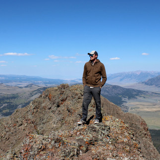
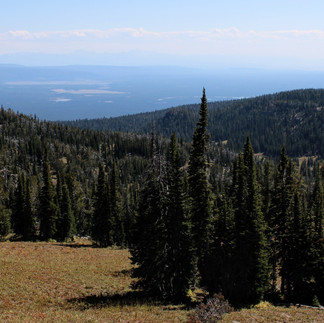
Another item that has taken up long-term residence on my list is to visit the summit of Sawtell Peak in the Centennial Mountains of East-Idaho! Situated on the north end of Island Park, and on the eastern-most edge of the Centennials, Sawtell Peak rises nearly 10,000 feet into Idaho's crisp blue sky. From the top you can see hundreds of miles in all directions. The distant Tetons, Pioneer Mountains of Montana, the greater Yellowstone Area, even the Ammon Foothills to the south are all visible on a clear day. I have driven past this peak for years, gazing up at the Radar station at its summit, wondering and yearning to see the world from that vista. I don't know why it has taken me this long to finally visit, but yesterday we decided to go, and go we did!
All I could think about on the drive up the mountain is how much my mom could NOT do this drive! In all respect to her, she would love the views, but the heights and sheer cliffs, lack of guardrails along a one-lane dirt road to the summit, and the bumps in the road would send her running off the mountain at the first turn. By far, this is one of the sketchiest roads I have ever driven. I got the tingles in the hands and feet (the same ones you get at great heights or in a dream where you are falling) as we drove around hairpin turn after hairpin turn. Hundred foot drops waited at each turn. We passed several vehicles on the way up, the juggle of cars made the whole experience even crazier. Nothing like the fear of falling and likely death to make you feel alive! When we reached the summit, the drive became more than worth it! Even before reaching the summit, views of the old caldera around Island Park, the Tetons, and the forests of Yellowstone were visible. From the top, Henry's Lake and the intricate topography of Montana came into view. We got lost in the views in every direction. I felt like a bird soaring high above the world below. Towns and homes were barely visible. I felt peace.
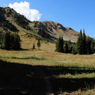
A family of mountain goats relaxed at the feet of the radar station at the summit. A surprise given there were another dozen people besides ourselves at the top! The goats seemed unfazed, and gradually left down a steep grassy slope back to the rocky cliffs of the mountain. Our goal this trip was to hike, which we still hoped to do, even after spending more than half an hour atop Sawtell Peak. As we drove down the mountain, we spotted a trailhead for Sawtell Peak Trail (National Forest Service Trail #165). With no information about where the trail goes, or how long it is, we embarked on a 6-8 mile trek across mountain faces then into the valley below. We were given great views of Sawtell Peak and other rocky cliffs and steep slopes of the Centennials. Bear and deer tracks were visible in the shaded mud of the trail, hawks soared at eye level over lower peaks and into the scattered pine forests. Yellow grasses and orange underbrush hinted that winter is coming. Fossils rested in grey limestones in the valley, while a thousand feet of lava flows sat atop Sawtell Peak and along the eastern slopes of the Centennials. The geologic history of theis region is fascinating! Yellowstone has heavily influenced regional tectonics, morphology, and more. Ancient mountain building events, periods of heavy glaciation, prehistoric oceans, and so much more have contributed to the rich and diverse landscape of East Idaho. The trail we followed is of moderate difficulty, with some steep spots. Most of what we hiked was generally flat as it followed the ridgeline before entering the valley below. We witnessed the diverse changes in geology along the trail as rock type and mountain shapes morphed before us. We stopped in the valley for lunch and a rest break, then returned to the car. My guess is this trail exits the Centennials in the north, though for all I know it could continue and connect to the Continental Divide Trail, end at an alpine lake, or circle back up to Sawtell. We didn't have the time or energy to see it to its end. That's okay, because what we did see and do was more than enough to satisfy our wanderlust for the day!
The drive back home was long. My fault, happily though! We took detour after detour, following the "scenic route" along forest roads such as Fish Creek Rd on the northern and eastern ends of Island Park. This dirt and paved logging road is in decent condition considering it is covered in snow 9 months of the year. We followed that for more than an hour, then turned into the hills east of Ashton, following a route I have driven many times. We crossed Ashton-Flagg Ranch road, then turned West to Ashton so we could have dinner at the 511 Main St diner. With bellies full of pizza and milkshakes, we continued south back to Idaho Falls taking farm roads past the Menan Buttes.
This all-day excursion was just what I needed after a long week! I highly recommend visiting the Centennial Mountains and Island Park. Please recreate responsibly and respectfully. There is so much beauty around us, it is staggering! As we researched hikes in the area, I realized just how little I've truly explored. I could hike and drive the rest of my life within a 4-hour radius of Idaho Falls, and still not see it all. For now, I am grateful for what I have seen, experienced, and felt. I am so grateful to call Idaho home!
Enjoy some of our favorite pictures from the trip!


😲😮😳😲😮😳
Yep, yep, that drive would not do for me!!!
Glad you shared what you saw! 👏😍